Recon Weather launches weather balloon soundings around severe storms. In 2027 we will launch from several vehicles at once to compare conditions across storm boundaries and around individual supercells.
National Weather Service balloons launch twice a day from stations that are often hundreds of miles apart. Temperature, moisture and wind near a storm can differ from those soundings. We add soundings close to individual storms, launched from more than one location at the same time.
The near-storm environment is heterogeneous on scales finer than the operational sounding network resolves. Simultaneous soundings across the inflow region of a single supercell will show differences in 0–1 km shear, storm-relative helicity, low-level moisture and CAPE large enough to change storm-scale parameters, differences that a single proximity sounding does not capture.
Balloon soundings are the primary measurement. IsoPods and vehicle instruments are secondary and are deployed when staffing allows.
Radiosondes we design and build. Full sondes measure temperature, humidity, pressure and wind. GPS-only sondes measure wind.
Ground stations that record surface pressure 20 times a second.
Instruments on team vehicles that record surface conditions while driving.
Each field day targets one of these.
Launch sondes on both sides of an outflow boundary or warm front within minutes of each other, and compare the wind, temperature and moisture profiles. Vehicle and IsoPod measurements locate the boundary at the surface.
Launch sondes at several positions around one supercell, including near inflow, far inflow and storm-modified environment, and compare the low-level wind profiles. Repeat the launches when possible to separate differences in location from changes over time.
Neither objective requires a tornado. Hail-producing and tornadic storms are both targets.
Source: our STING methods manuscript (draft v0.15, October 2026). Numbers are from individual flights and are reported as measured, not as guaranteed accuracy.
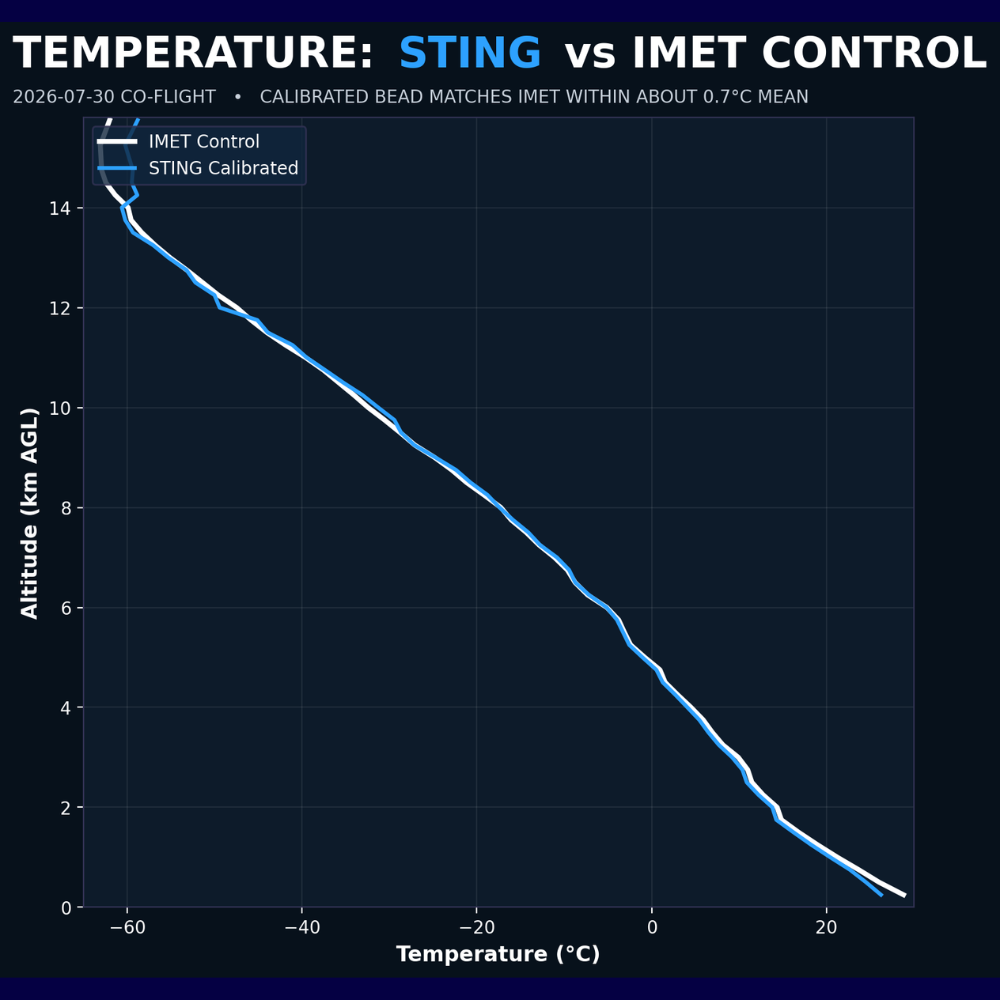
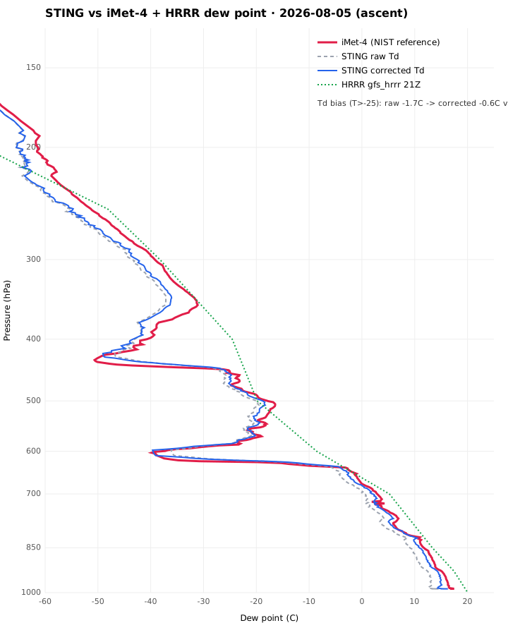
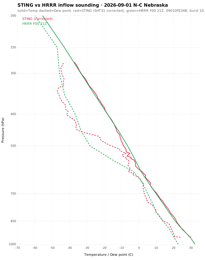
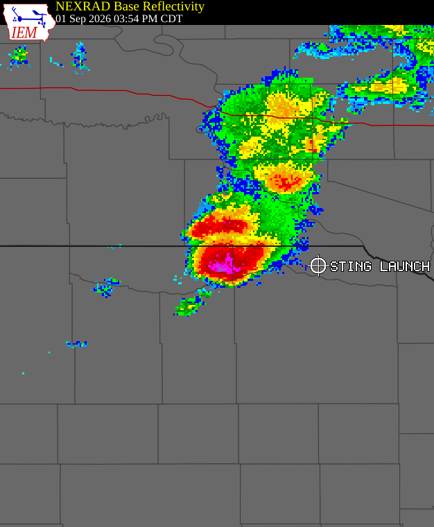
Figures from our reference co-flights and the September 1 inflow sounding.
STING flights in the 2026 season, including failed and partial flights. Each has a full field report.
| Date | Location | Type | Result |
|---|---|---|---|
| 2026-06-21 | McCook area, NE | Engineering test | Fair-weather profile from the surface to about 6,150 m.Data ends mid-climb; cause not confirmed. |
| 2026-06-23 | Eastern Colorado | Near-storm sounding | Sampled inflow to a hailstorm about 6 miles away. Low-level winds near 57 kt; profile to about 6,970 m. The storm produced 3-inch hail.Data ends after about 17 minutes; cause not confirmed. |
| 2026-06-29 | Stoughton, WI | Engineering test | Reached 9,014 m. Signal ended when battery voltage dropped below about 3.4 V; the radio link stayed healthy.Launched with a partly charged battery. |
| 2026-06-30 | Stoughton, WI | Range test | Antenna comparison. New antenna about 20 dB stronger. Range 32.5 mi, altitude 10,128 m.Ended on cold-battery failure. |
| 2026-07-01 | Stoughton, WI | Range test | Range 54.8 mi, altitude 11,747 m. Sonde went silent in the cold and restarted on descent.Planned storm collapsed; flown as a range test. |
| 2026-07-14 | Stoughton, WI | Engineering test | Closed enclosure to keep the battery warmer. Altitude 14,135 m and first confirmed balloon burst.Weather sensor faulty; no temperature or humidity data. |
| 2026-07-21 | Gulf coast near Pensacola, FL | Near-storm sounding | Outer winds of Tropical Storm Bertha. 40 kt onshore low-level jet near 650 m; profile to 11,832 m and about 62 mi.Older, uncalibrated temperature sensor. |
| 2026-07-26 | Stoughton, WI | Engineering test | First flight of a new humidity and pressure sensor package. Signal ended at 11,865 m with the link healthy at about 63 mi.Ended on cold-battery failure. |
| 2026-07-28 | Stoughton, WI | Engineering test | First flight of the bead temperature sensor. Altitude 14,838 m, range about 87 mi.Temperature not yet calibrated on this flight. |
| 2026-07-29 | Stoughton, WI | Reference co-flight | STING and a NIST-traceable iMet-4 on one balloon. Temperature calibration fitted; agreement within about 0.8 °C to the tropopause.Sondes not recovered. |
| 2026-07-30 | Stoughton, WI | Reference co-flight | Calibration confirmed on a second flight: temperature within about 0.85 °C. Pressure method above 400 hPa confirmed.First humidity correction later replaced. |
| 2026-08-02 | Stoughton, WI | Engineering test | Final design with a 500 mAh battery. Reached balloon burst at 14,102 m with signal held through descent. |
| 2026-08-02 | Stoughton, WI | Engineering test | Side-mounted humidity sensor reduced self-heating by 1 to 4 °C. Burst at 11,201 m.Did not fix the low-level humidity error. |
| 2026-08-02 | Stoughton, WI | Engineering test | Tested the humidity sensor's built-in heater. Too weak to help. Burst at 9,580 m.Diagnosis superseded the next day. |
| 2026-08-03 | Stoughton, WI | Engineering test | Humidity sensor from a verified batch read down to 4%, matching the model. Earlier readings stuck near 17% traced to a bad sensor batch. |
| 2026-08-05 | Stoughton, WI | Reference co-flight | Humid-day co-flight. Humidity correction fitted, R² = 0.98 over 453 matched points. Dew point error reduced from 1.68 to 0.60 °C. |
| 2026-08-09 | Stoughton, WI | Range test | Lithium-battery variant in extreme cold. Signal stopped at 13,419 m and −60 °C while climbing.Failed; cause not yet determined. |
| 2026-08-18 | Sun Prairie, WI | Severe-warned launch | Environment of a tornado-warned storm. Strong deep-layer shear, modest instability. Profile to 12,462 m, within 0.6 °C of the model.Ended on cold-battery failure before burst. |
| 2026-08-20 | Central Nebraska | Storm intercept | Launched under a 60+ dBZ hail core. Balloon burst at 3,915 m; the sonde kept transmitting through heavy rain and a fast descent.Only the lowest ~1.8 km is a usable profile. |
| 2026-09-01 | North-central Nebraska | Near-storm sounding | Inflow side of a supercell, ahead of the rain core. Burst at 10,257 m. About 3,000 J/kg CAPE, 57–63 kt deep-layer shear. Mean temperature difference from the model 0.07 °C. |
Each deployment is documented in a field report. Planned papers, in order:
Funds go to radiosondes, helium, IsoPods and vehicle instruments. Launches are shared through the free app and livestreams.